
'Gener' continues to endanger extreme Northern Luzon
Source: pagasa.dost.gov.ph
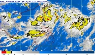
The center of Tropical Storm "Gener" was estimated based on satellite and surface data at 360 km East Northeast of Aparri, Cagayan or 290 km East Southeast of Basco, Batanes (20.0°N, 125.0°E). Maximum sustained winds of 105 kph near the center and gustiness of up to 135 kph.
Tropical Storm "Gener" is expected to be at 210 km East Northeast of Basco, Batanes by tomorrow morning and at 340 km North of Basco, Batanes by Wednesday morning. By Thursday morning, it is at 530 km NNW of Basco Batanes outside the Philippine Area of Responsibility.
Tropical Storm "Gener" is expected to enhance the Southwest Monsoon that will bring rains and moderate to strong winds over Luzon and Visayas especially the western section.
Residents living in low lying and mountainous areas are alerted against possible flashfloods and landslides. Likewise, those living in coastal areas under Public Storm Warning Signal #2 are alerted against big waves or storm surges generated by this tropical cyclone.
Estimated rainfall amount is from 10-20 mm per hour (heavy-intense) within the 700 km diameter of the Tropical Storm.
Fishing boats and other small seacrafts are advised not to venture out into the Seaboards of Central and Southern Luzon, Visayas and eastern seaboard of Mindanao due to the combined effect of Tropical Storm "Gener" and the Southwest Monsoon.
Public storm warning signal:
Signal no.1
Cagayan Including Calayan
and Babuyan Group and
Batanes Group of Islands
and Babuyan Group and
Batanes Group of Islands
Signal no.2
Isabela, Kalinga and
Apayao
Apayao
(PAGASA)