

Typhoon 'Huaning' enters PAR
2013-Jul-10 13:49
2025-Jan-09 11:52
Typhoon "Soulik" on Wednesday has entered the Philippine Area of Responsibility (PAR) and has been named "Huaning by the state weather bureau .
"Huaning" is the first cyclone to visit the country this month and the eighth for the year.
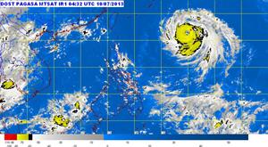
Weather Forecaster Alvin Pura said that as of 11:00 a.m. "Huaning" was located at 1,220 km east of Itbayat, Batanes packed with maximum winds of 175 kph near the center and gustiness of up to 210 kph.
Pura said "Huaning" is still expected to further intensify as the cyclone will likely pass near extreme Northern Luzon before going to Taiwan.
"Inaasahan natin pa ito lalakas pero wala po tayong kategoryang super typhoon (It is expected to gain strength but still not in the category of a super typhoon)," he explained. No public storm warning signal has been raised.
Pura said their forecast models indicated Huaning is not likely to have any direct effect on the Philippines, but is expected to enhance the southwest monsoon bringing rains over western section of the country on Thursday.
He also noted the tropical storm is not expected to make landfall in any part of the country.
Pura added Huaning would continue to move at west northwest at 20 kph and expected to leave the country by Saturday.
Pura also said that strong to gale-force winds associated with Typhoon Huaning may affect the eastern seaboards of Central and Northern Luzon.
"Fishing boats and other small sea craft are advised not to venture out into the sea while larger sea vessels are alerted against big waves," PAGASA said.
PAGASA also said Typhoon "Huaning" is expected to be at 820 km east of Itbayat, Batanes by Thursday morning; by Friday morning expected to be at 450 km northeast of Itbayat, Batanes and by Saturday morning to be at 450 km North of Itbayat, or in the vicinity of Northern Taiwan outside PAR. (PNA)