
Typhoon 'Huaning' intensified as it maintains speed and direction
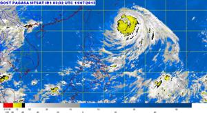
At 10:00 AM today, the eye of Typhoon "Huaning" was located based on all available data at 810 km East Northeast of Itbayat, Batanes (22.2°N, 130.5°E).
Maximum sustained winds of 185 kph near the center and gustiness of up to 220 kph. Forecast to move West Northwest at 20 kph.
Typhoon "Huaning" is expected to be at 450 km Northeast of Itbayat, Batanes by tomorrow morning and at 490 km North of Itbayat, Batanes by Saturday morning or 80 km Northwest of Northern Taiwan and outside the Philippine Area of Responsibility (PAR).
Public storm warning signal:
Signal no. 1 (Winds of 45-60 kph is expected within the next 36 hours) – Batanes Group of Islands
Potential Impacts of the Winds:
- Twigs and branches of trees may be broken.
- Some banana plants may tilt or land flat on the ground.
- Rice in flowering stage may suffer significant damage.
- Some nipa and cogon houses may be partially unroofed.
- Sea travel of small seacrafts and fishing boats is risky.
- Some banana plants may tilt or land flat on the ground.
- Rice in flowering stage may suffer significant damage.
- Some nipa and cogon houses may be partially unroofed.
- Sea travel of small seacrafts and fishing boats is risky.