
'Kristine' now a tropical storm; signal no. 1 up in parts of PH
2024-Oct-22 09:48
2024-Oct-26 01:38
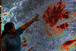
WEATHER WATCH. Aleandra Rivera, Weather Unit Supervisor of the Quezon City Disaster Risk Reduction and Management Office, leads the monitoring of the track of Tropical Depression Kristine on Monday (Oct. 21, 2024). Kristine has intensified into a tropical storm, packing maximum sustained winds of 65 kph near the center, and gustiness of up to 80 kph, the weather bureau said Tuesday (Oct. 22, 2024) (PNA/Joan Bondoc)
MANILA – Tropical cyclone Kristine has intensified into a tropical storm, packing maximum sustained winds of 65 kph near the center, and gustiness of up to 80 kph, the weather bureau said Tuesday.
It was last tracked 390 km. east of Virac, Catanduanes.
Signal no. 1 was hoisted over the eastern and central portions of mainland Cagayan (Piat, Santo Nino, Camalaniugan, Tuao, Lal-Lo, Enrile, Gonzaga, Alcala, Amulung, Santa Teresita, Baggao, Buguey, Solana, Rizal, Santa Ana, Tuguegarao City, Gattaran, Peñablanca, Iguig, Lasam, Aparri, Allacapan), Isabela, Quirino, the southern portion of Nueva Vizcaya (Alfonso Castañeda), Aurora, the eastern portion of Rizal (Tanay, Pililla, Jala-Jala), the east portion of Laguna (Majayjay, Magdalena, Pila, Santa Cruz, Pagsanjan, Luisiana, Cavinti, Lumban, Kalayaan, Paete, Pakil, Pangil, Siniloan, Famy, Santa Maria, Mabitac, Nagcarlan, Liliw), the northern and eastern portions of Quezon (Tagkawayan, Guinayangan, Buenavista, San Narciso, San Andres, General Nakar, Pitogo, San Francisco, Calauag, Pagbilao, Infanta, Lopez, Catanauan, Mulanay, Unisan, General Luna, Plaridel, Quezon, Alabat, Sampaloc, Padre Burgos, Macalelon, Mauban, Perez, Agdangan, Gumaca, Atimonan, Real, Lucena City, Lucban, City of Tayabas) including Polillo Islands, Marinduque, Romblon, Camarines Norte, Camarines Sur, Catanduanes, Albay, Sorsogon, and Masbate including Ticao Island and Burias Island.
Also under signal no. 1 are Eastern Samar, Northern Samar, Samar, Leyte, Biliran, and Southern Leyte, Dinagat Islands, and Surigao del Norte including Siargao-Bucas Grande.
Strong winds will prevail in areas where signal no. 1 is hoisted, the Philippine Atmospheric, Geophysical and Astronomical Services Administration (PAGASA) said.
Kristine and the northeasterly wind flow will also bring strong to gale-force gusts over Batanes, Babuyan Islands, Ilocos Region, Palawan, Romblon, Aklan, Antique, Negros Island Region, Central Visayas, Southern Leyte, Zamboanga del Norte, Northern Mindanao, Dinagat Islands, Surigao del Norte, Agusan del Norte, Sarangani, Davao del Sur, and Davao Oriental.
Meanwhile, a gale warning is hoisted over the eastern seaboard of Luzon, the southern seaboard of Southern Luzon, and the eastern seaboard of Visayas.
Sea travel is risky for all types or tonnage of vessels. PAGASA added that mariners must remain in port or, if underway, seek shelter or safe harbor as soon as possible until winds and waves subside.
PAGASA now forecasts the cyclone to land over Isabela on Wednesday evening, and exit the Philippine Area of Responsibility on Friday. (PNA)