'Kristine' accelerates outside PAR; 'Leon' now a tropical storm
2024-Oct-26 16:00

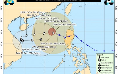
Track of Severe Tropical Storm Kristine (PNA/PAGSA-DOST)
MANILA – Severe Tropical Storm Kristine (international name Trami) accelerated westward out of the Philippine Area of Responsibility (PAR) on Friday afternoon, according to the Philippine Atmospheric, Geophysical and Astronomical Services Administration (PAGASA).
In its 5 p.m. bulletin, the weather bureau said the center of the storm was located 410 kilometers west of Sinait, Ilocos Sur at 4 p.m., maintaining maximum sustained winds of 95 kph near the center, with gusts reaching up to 115 kph.
Although Kristine exited PAR at approximately 2 p.m., strong storm-force winds extended up to 580 km from Kristine's center, impacting several areas in Luzon.
Tropical Cyclone Wind Signal No. 1 is still up in Ilocos Norte, Ilocos Sur, La Union, Pangasinan, Apayao, Kalinga, Abra, Mountain Province, Ifugao, Benguet, Cagayan including Babuyan Islands, Isabela, Quirino, Nueva Vizcaya, Nueva Ecija, Tarlac, Zambales, Bataan, Pampanga, Bulacan, Metro Manila, the northern portion of Rizal (Cainta, Rodriguez, San Mateo, City of Antipolo, Taytay), and the northern portion of Cavite (Ternate, Naic, Tanza, Rosario, Bacoor City, Kawit, Noveleta, Cavite City, City of General Trias, Imus City, Maragondon).
"The wind signals warn the public of the general wind threat over an area due to the tropical cyclone. Local winds may be slightly stronger/enhanced in coastal and upland/mountainous areas exposed to winds. Winds are less strong in areas sheltered from the prevailing wind direction," PAGASA said.
"Minimal to minor impacts from strong winds are possible within any of the areas under Wind Signal No. 1," it added.
Meanwhile, the tropical depression outside PAR has intensified into a tropical storm and will be locally named Leon (international name Kong-rey).
PAGASA noted that due to the southwesterly wind flow triggered by both Kristine and Tropical Storm Leon, strong to gale-force gusts are expected across Mimaropa, Bicol Region, Visayas, Dinagat Islands, Surigao del Norte, Northern Mindanao, Zamboanga Peninsula, Bangsamoro Autonomous Region in Muslim Mindanao (BARMM), Soccsargen, and Davao Region.
While all storm surge warnings have been lifted, PAGASA has maintained a gale warning for northern and western Luzon seaboards.
Kristine is projected to continue its westward course over the West Philippine Sea until Saturday, with a possible counterclockwise loop expected Sunday and Monday outside PAR.
"This tropical cyclone is forecast to gradually intensify over the West Philippine Sea. While it is likely that the tropical cyclone will remain at severe tropical storm category within the next two days, the chance for it to be upgraded into a typhoon is not ruled out. However, a weakening trend is expected by early next week due to a possible surge of northeasterly wind flow over the West Philippine Sea," PAGASA said. (PNA)
