Signal no. 1 up in parts of N. Luzon as 'Marce' intensifies
2024-Nov-05 10:05

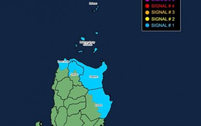
Tropical cyclone wind signal no. 1 hoisted over parts of Northern Luzon as of 5 a.m. on Nov. 5, 2024 (PNA/PAGASA)
MANILA – Severe Tropical Storm (STS) Marce (international name Yinxing) further intensified and is nearing the typhoon category, the weather bureau said Tuesday.
It packs maximum sustained winds of 110 kilometers per hour (kph) near the center and gustiness of up to 135 kph.
The STS was located 735 km. east of Baler, Aurora as of 4 a.m.
Tropical cyclone wind signal no. 1 is hoisted over Batanes, Cagayan including Babuyan Islands, the northern and eastern portions of Isabela (Maconacon, San Pablo, Palanan, Dinapigue, Santa Maria, Cabagan, Tumauini, Santo Tomas, Ilagan City, Divilacan, San Mariano), the northern portion of Apayao (Santa Marcela, Luna, Calanasan, Flora, Pudtol), and the northern portion of Ilocos Norte (Pagudpud, Dumalneg, Adams, Bangui, Burgos, Pasuquin, Vintar). Strong winds will prevail in these areas.
Minimal to minor impacts from strong winds are possible within any areas under Wind Signal No. 1.
The highest Wind Signal that may be hoisted during the occurrence of MARCE is Wind Signal No. 4.
Due to the northeasterly wind flow, strong to gale-force gusts will also prevail across Ilocos Sur, Aurora, Quezon, and Camarines Norte.
A gale warning is hoisted over northern and eastern seaboards of Northern Luzon.
Sea travel is risky for all types or tonnage of vessels, the Philippine Atmospheric, Geophysical and Astronomical Services Administration (PAGASA) forecaster said.
Meanwhile, scattered rain showers and thunderstorms will be experienced over Cagayan Valley, Apayao, Kalinga, Quezon, and Bicol Region.
Moderate to heavy rains in those areas could result in flash floods or landslides.
Marce could make landfall in the vicinity of Babuyan Islands or over the northern portion of mainland Cagayan on Thursday night or Friday.
However, the forecast track may still change and bring the landfall point to the mainland Cagayan-Isabela area.
The cyclone is forecast to exit the Philippine Area of Responsibility (PAR) on Friday night or Saturday, PAGASA said. (PNA)
